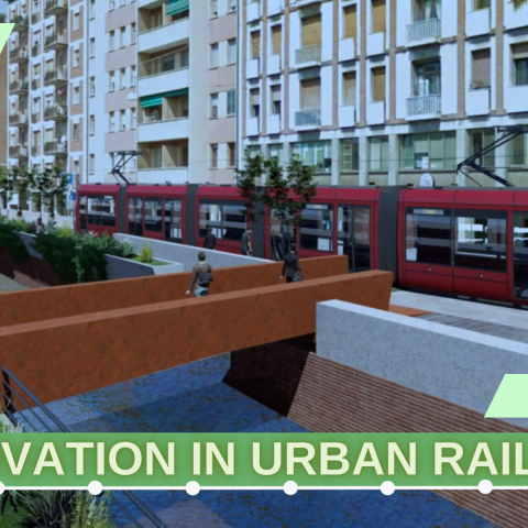
Works begins on the Red Line: the tram returns to Bologna!
Sixty years after the closure of the last line (the service ended on 3 November 1963), the tram in Bologna is starting up again. With a brand new network, of which the foundation stone was laid on 26 April, in the presence of the mayor of Bologna Matteo Lepore, the city councillor for Public Works […]
Sixty years after the closure of the last line (the service ended on 3 November 1963), the tram in Bologna is starting up again. With a brand new network, of which the foundation stone was laid on 26 April, in the presence of the mayor of Bologna Matteo Lepore, the city councillor for Public Works Valentina Orioli, and the president of the Borgo Panigale Reno district, Elena Gaggioli, construction site ‘A’ of the Red Line was in fact started, the first of four rail lines envisaged by the PUMS of the metropolitan city of Bologna approved in 2019, and marked by different colours:
– Red Line: Terminal Emilio Lepido-Capolinea Nord Michelino-Facoltà di Agraria/CAAB
– Green Line: Corticella-Deposito Due Madonne
– Yellow Line: Rastignano-Casteldebole
– Blue Line: Casalecchio-San Lazzaro
The tram network project envisages not only the construction of the infrastructure, with innovative features, but the redevelopment of many areas of the city adjacent to the tramway, new traffic solutions and the creation of new cycle paths, for the purposes of increasingly integrated and sustainable mobility. The PUMS envisages that at least 256,000 daily trips made by car and motorbike will be made by other modes of transport, including the tram.
The Red Line, the new Bologna’s tramway
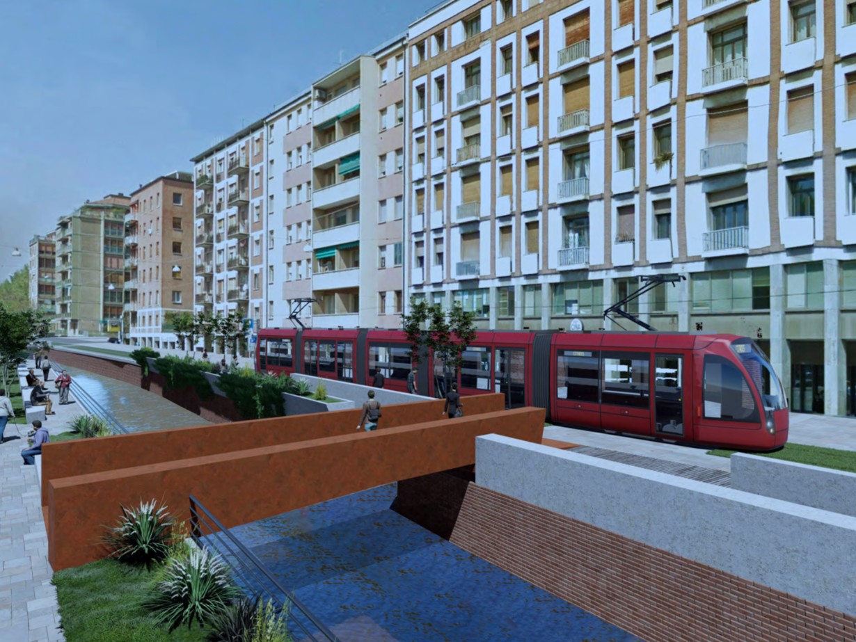
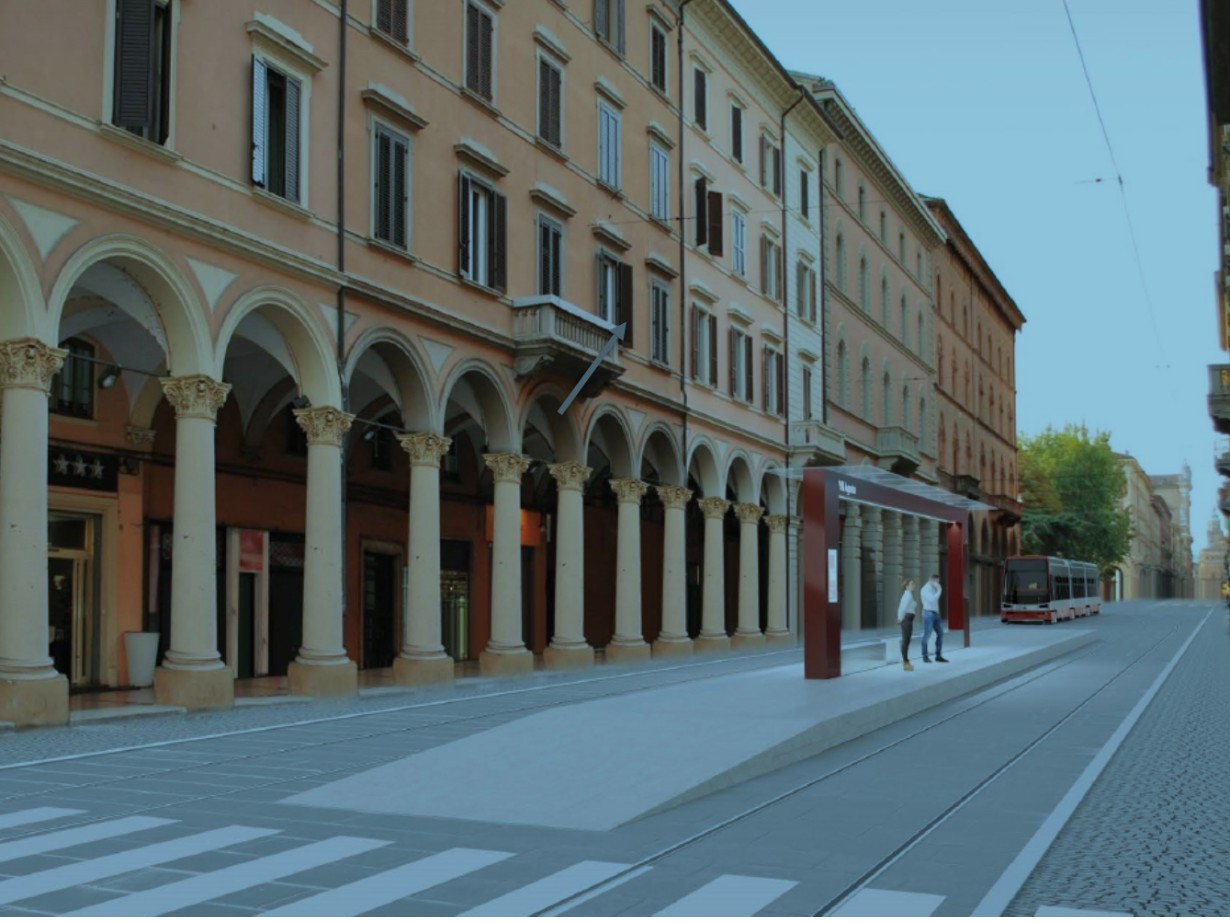
From om the Emilio Lepido terminus (West terminus), the Red Line will run along the Via Emilia axis, serving the Ospedale Maggiore hospital and the historic centre, and continue towards the railway station, Bolognina and the trade fair district. From here, the line will split into two sections, connecting the Michelino car park (northern terminus) and the Faculty of Agriculture and the Bologna Food Centre (CAAB – eastern terminus).
The line will be 16.5 km long, 2 of which will be battery-operated; power will be provided by the overhead line, except for the section in the historic centre, where the project does not envisage the construction of a contact line, and the tram in the specific section will move by means of on-board batteries, following the example of the French city of Nice.
The tramway seat will be at least 90 % reserved, and access to it will be allowed only to emergency and rescue vehicles. The seat will be raised 5-7 cm above the road lanes, and there will be no separation barriers. The stops, a total of 31 in addition to the 3 terminuses, will be located in a special structure, with a covered section, and will allow access to the vehicles without having to overcome any differences in level or steps. User access to the stops will be by means of traffic light regulation.
The line will connect areas where new urban settlements and very important residential areas are planned, such as Borgo Panigale, Santa Viola, Bolognina, San Donato and the Pilastro, thus guaranteeing sustainable accessibility to them. The line’s route will also integrate with other public transport systems with infrastructure, on rail and road, already realised or financed.
Redevelopment projects
Work on the red line started in Borgo Panigale, with the construction of the Emilio Lepido Terminal, the technical area and depot for rolling stock, offices and, as part of the area redevelopment project, also an interchange car park with more than 380 parking spaces, easily accessible from the nearby motorway junction, from which users will reach the tram terminus via a subway, and a multi-purpose hall for use by citizens. he area adjacent to the INA village will instead be transformed into a public park of over 38,000 square metres with 300 new trees, spaces and pedestrian paths, and areas dedicated to sports. To the north of the nearby depot, a new wooded area will be created with 856 new trees.
Between Via Marco Emilio Lepido, Via Persicetana and Via De Gasperi, a new and more rational two-level road link will be created; the intervention will allow for the elimination of traffic lights and a better fluidification of traffic flows, benefiting noise and air quality, and a safer journey for pedestrians and cyclists, for whom several kilometres of cycle paths are planned. For the Red Line alone, for example, up to 12 km of cycle paths and 6 new cycle stations are planned.
The E6 construction site of the opposite terminus, at the Michelino – Fiera Terminal, will also start shortly. The terminus will be located near the trade fair district, one of the most important in Italy, the A14 gate and the Michelino parking area. The terminal is to become an integrated mobility centre, an interchange node between the tram line and urban and suburban car lines; the tramway is to provide a fast connection for those travelling to the exhibition centre and the city centre. The Michelino car park, capable of 400 parking spaces, will be able to take on the important function of an interchange on all days of the year, and will no longer be limited to the trade fair calendar.
The work also includes the reorganisation of the road system in the area and the level part of the Michelino car park. The preliminary phase of work on the ‘E4’ and ‘E5’ sites in Viale Europa and Via della Fiera will then begin in early May, which will involve the elimination of the central reservation and the construction of temporary street lighting. This will be followed by work on the underground utilities.
The red line should be inaugurated by 2026, while 2030 is the target for the opening of the four lines, which when fully operational should reach an extension of 57 km and transport 300,000 passengers a day.
by Stefano Alfano